The Mercator projection is a map projection (a way to present the spherical Earth surface into a flat 2-D map) presented by Flemish cartographer Gerardus Mercator in 1569. It was the standard map projection for some time, because it does preserve all angles in their true shape (i.e. it is a conformal map projection). This means that if you measure an angle on the map you get the right direction in the real world - a very useful feature if you're using the map for navigating. However, preserving the angle leads to severe distortions of the surface area, especially in the higher latitudes where countries appear much larger than they actually are. For example on the Mercator Projection, Greenland (the largest non-continent island in the world) is shown to be much larger than Australia (the smallest continent), although the latter in reality is nearly 4 times as big. Other examples of regions having distorted sizes and shapes due to the Mercator Projection can be explored in this link.
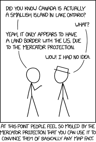
Cueball uses White Hat's mistrust of the Mercator projection to convince him of ridiculous facts about Canada, namely that it is simply a small island in Lake Ontario. Map projections are generally continuous functions, meaning that they never map a disconnected space onto a connected one and therefore can never give the false impression that two areas that don't border each other do.
The title text continues on these falsehoods, claiming that the Great Lakes are simply "water on the far side of Canada Island", and that it is possible to drive directly into Alaska from the Pacific Northwest region of the US (in reality, Canada has a border with the contiguous states and Alaska). Cueball can possibly make these statements as Canada is a country in the northern regions, where the Mercator Projection would show it larger than it actually is. However, Canada is the second largest country in the world by total area (land and water), after Russia.
The Mercator Projection was previously mentioned in 977: Map Projections of "what your favorite map projection says about you". People who preferred the Mercator Projection was listed as "You're not really into maps." It is also the second comic in a row that relates somehow to latitudes. Bad Map Projections is a series in xkcd, showing that it is really something on Randall's mind.
It is not the first time Cueball (or Randall) tries to spread misinformation, for instance it also has White Hat as the target in 1677: Contrails, but it can also be other people that are fooled like in 1405: Meteor.