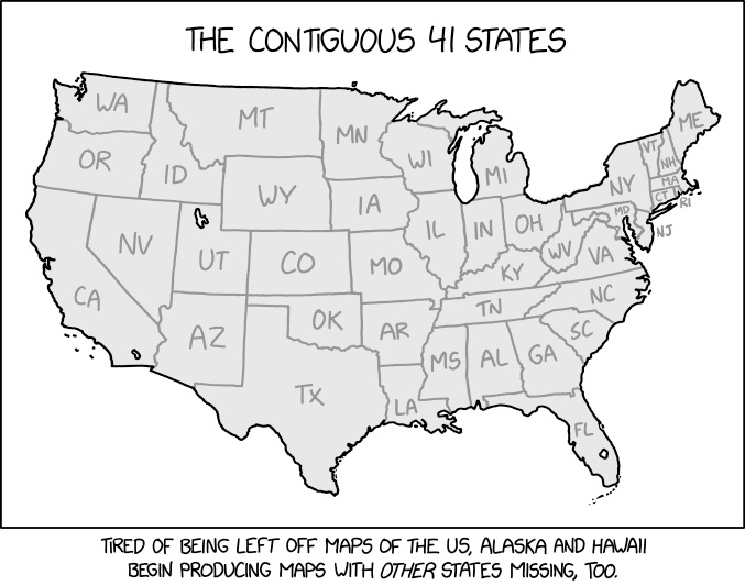
The states missing from the comic map.
The United States of America is composed of 50 states, 48 of which are contiguous – meaning they share common borders. Two states are separated from the other 48 states, Alaska and Hawaii. Alaska, purchased from Russia in 1867, is separated from the rest of the United States by the country of Canada (or at least appears to be as a result of the Mercator Projection). Hawaii, annexed in 1898, is a group of islands in the Pacific Ocean. As these states are not contiguous to the rest of the 48 states, they may be omitted from maps of the United States. Typically, these 2 states are included in inset maps, separate sections usually placed at the bottom of the main map.
The United States also includes 5 permanently inhabited territories (Puerto Rico, U.S. Virgin Islands, Guam, Northern Mariana Islands, American Samoa), which are not contiguous with states. Puerto Rico may become a state. The District of Columbia is not (yet) a state, but is contiguous with the states.
The map in this comic is "Alaska and Hawaii's revenge", with seven additional states removed: North Dakota, South Dakota, Nebraska, Kansas, New Mexico, Pennsylvania, and Delaware. Most of these are accomplished by eliminating a column of states: North Dakota, South Dakota, Nebraska, and Kansas. Oklahoma and Texas, which are directly south of these, are slid over to the west into the space freed up by deleting New Mexico. The other two deleted states are Pennsylvania and Delaware, with the states to their south and north slid/extended to fill the gap.
The map is also missing Isle Royale, Michigan, the third-largest island in the contiguous U.S. This seems to be a legitimate oversight, as the map includes numerous smaller islands in detail, including Michigan's Beaver Island and North Manitou Island. Even the non-contiguous Northwest Angle of Minnesota is depicted. (The Eastern Shore of Virginia, which is not connected to the rest of Virginia and only borders Maryland, is also not shown—presumably to make way for New Jersey replacing much of the Delmarva Peninsula).
Some states, while not removed, are significantly distorted. Iowa and Missouri lose their contours with the Missouri River, while Wyoming's eastern border is crooked. The eastern border of Maryland follows the Delaware river with New Jersey. The border between Oklahoma and Arkansas is moved west. Western New York is wider in the comic than it is in reality. Also, the location of the Niagara River, separating Lake Erie and Lake Ontario, is much less distinct than in reality.
The United States did have exactly 41 states for a few days in 1889, from the admission of Montana, the 41st state, on November 8, to the admission of Washington (the state, not DC), the 42nd state, on November 11. However, it was not the same 41 as shown here; for example, Pennsylvania and Delaware were two of the original 13 states (Delaware calls itself the first state, based on date of ratification of the Constitution) and Arizona and Oklahoma did not become states until the early 1900s.
The title text riffs on synonyms for "shared borders", which, according to Randall, linguists are inventing more of (while claiming they already existed) to make life more complicated for modern English users, for obscure reasons.
In fact, 'contiguous', 'coterminous', and 'conterminous' all date from early modern English, early-to-mid 17th century (just after the time of Shakespeare). 'Coterminous' and 'conterminous' are alternate spellings from the same Latin root ('cum' + 'terminus'), whereas 'contiguous' is from a different root (Latin 'contiguus'). Randall, facetiously, accuses linguists of having fabricated this history.
'Conterguous' is a neologism by Randall, though he blames it on linguists, consistent with his claim that they made up all the others. It is a portmanteau of 'CONTERminous' and 'contiGUOUS'. It is etymologically absurd (the prefix 'conter-' is meaningless). Its 'top-down' introduction into the language would simply be for the purpose of messing with people's minds, as Randall suggests. However, should the word catch on with English speakers, perhaps precisely because it is a joke, its 'bottom-up' entry into the language is certainly possible. One could then argue just how much Randall would have to answer for.
Three years later Randall made the opposite type of map, where he added 14 states and asks people to label all 64 (of 50) states in 2868: Label the States.