Bad Map Projection: ABS(Longitude)
Positive vibes/longitudes only
Positive vibes/longitudes only
This is the sixth comic in the series of Bad Map Projections displaying Bad Map Projection #152: ABS(Longitude). It came about 15 months after the fifth 2613: Bad Map Projection: Madagascator (#248), and was followed 11 months later by 2951: Bad Map Projection: Exterior Kansas (#45).
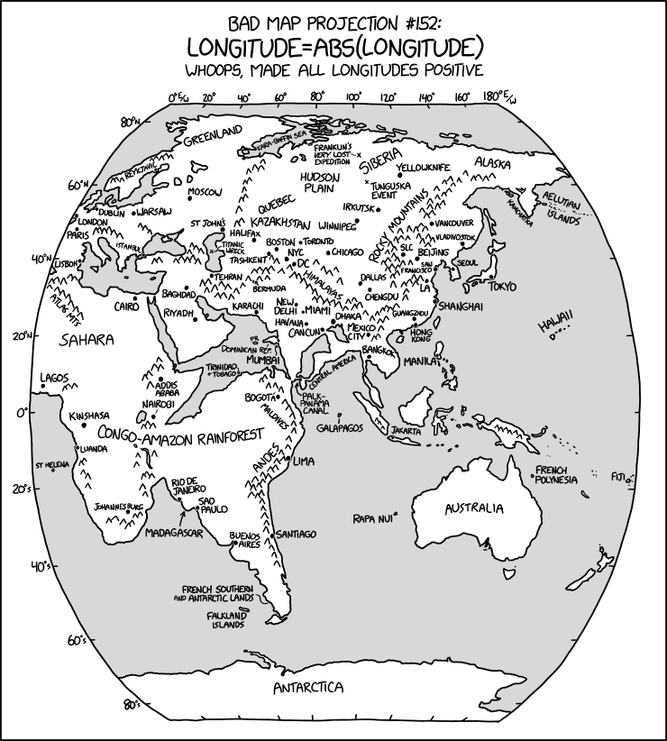
In this map, Randall has plotted the world map featuring all the landmasses from both western and eastern hemispheres. But the longitudes west of the prime meridian, normally given negative values from 0° to -180°, have been made positive using the "ABS()" function that gives the absolute value by effectively stripping off the minus sign from any value. This results in the features on one side of the world being overlaid upon those of the other side, but mirrored. A similar concept was explored earlier in 1500: Upside-Down Map. The caption "Whoops, made all longitudes positive" is similar to the caption in 2256: Bad Map Projection: South America ("Oops, all South Americas!"). That was a reference to the cereal Oops! All Berries.
Thanks to the relative sparsity of western continents (most prominently the Americas, but also roughly half of Antarctica, the westernmost parts of Europe and Africa, the easternmost part of Siberia, and multiple Pacific islands), and the landless expanses of the Pacific, this is surprisingly not too dissimilar to an east-only fragment of a world map. Just with the reversed 'new world' lands added to the usual extents of continents of Africa and Eurasia and the somewhat familiar notable Antarctic Peninsula being recognizable but in an odd position (and reversed) with no sign of the Ross and Weddel Seas (as eastern-Antarctic landmass takes precedence). Most continents can be traced out, but North America overlaps so much with Asia that most of its outlines are hidden.
Some features of the real world disappear, such as the English Channel, the North American Great Lakes, and the Strait of Gibraltar. The Arabian Sea becomes a lake as South America cuts it off from the rest of the Indian Ocean (Indian-Pacific Ocean?). To further interest the map-connoisseur, various locations are marked and dotted upon their genuine or reflected positions, putting into close proximity various locations that have (mainly) trans-Atlantic separation in reality. Some of these locations have been renamed in this projection by combining the names of newly overlapping locations. These are:
- The "Palk-Panama Canal", combining the Palk Strait between India and Sri Lanka with the Panama Canal in Central America.
- The "Congo-Amazon Rainforest", combining the world's two largest tropical rainforests, the Congo in Africa and the Amazon in South America.
- The "Hudson Plain", combining Hudson Bay in North America with the West Siberian Plain.
- The "Kara-Baffin Sea", combining the Kara Sea to the north of Russia with Baffin Bay between Canada and Greenland.
Additionally in northern Siberia is the label "Franklin's very lost expedition". Franklin's lost expedition was an attempt to find a passage from the Atlantic to the Pacific through the Arctic passage. Naturally, a sea voyage ending up in the middle of a large landmass would be considered very lost.[citation needed]
The title text references titles found in relaxing music videos called "positive vibes only", attempting to make the listener feel more positive and relaxed. Here, Randall adds his map projection, making it "positive vibes/longitudes only".
Correct formula
Possible correct formulae to get only positive longitudes of 0°<LONGITUDE≤360°, especially from the typical map range of -180°≤LONGITUDE≤+180°, are:
- LONGITUDE=LONGITUDE+360*FLOOR(1-LONGITUDE/360)
- LONGITUDE=360-(360-LONGITUDE) MOD 360;
These may assist in creating a world map centered on the Pacific, not too dissimilar to the one portrayed in 503: Terminology, which might be the conceit behind this comic's 'error'.