Dubious Islands
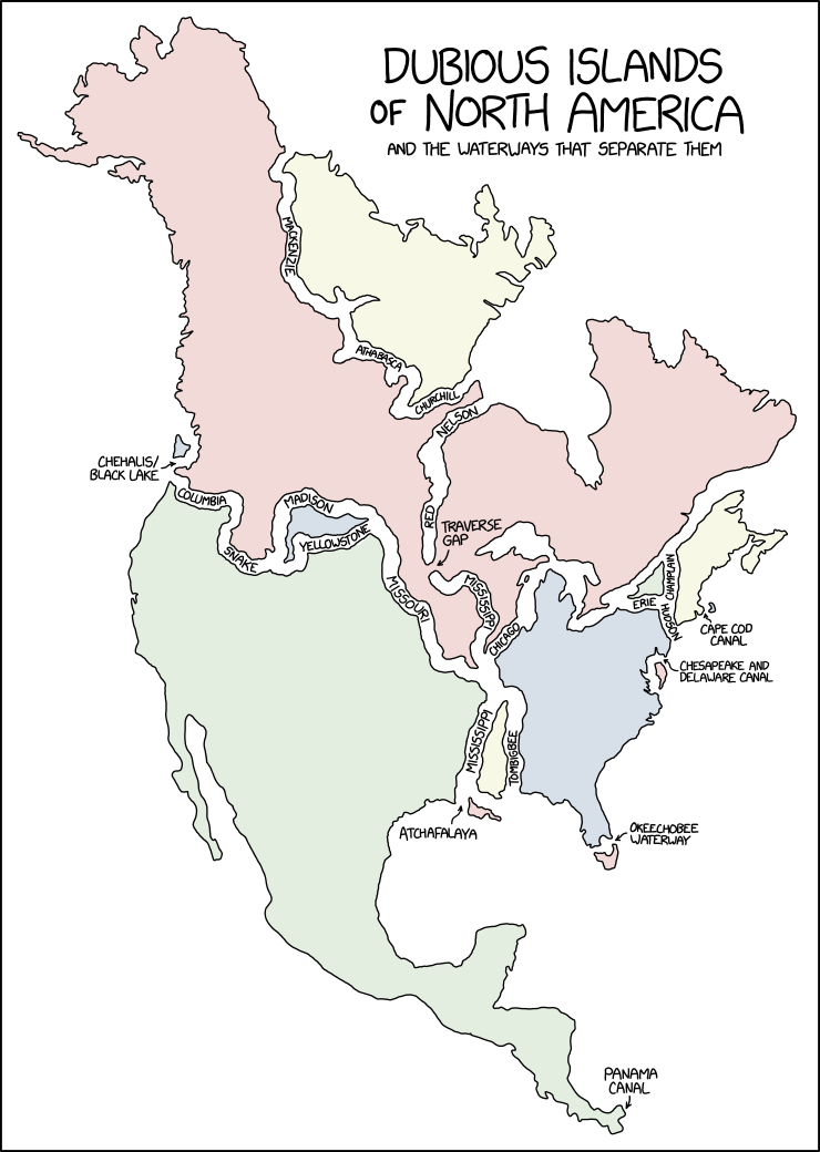
Running for office in Minnesota on the single-issue platform 'dig a permanent channel through the Traverse Gap because it will make this map more satisfying.'
Running for office in Minnesota on the single-issue platform 'dig a permanent channel through the Traverse Gap because it will make this map more satisfying.'
The definition of "island" is a piece of subcontinental land completely surrounded by a body (or perhaps bodies) of water. In most cases we don't count rivers and canals as the surrounding bodies,[actual citation needed] although small pieces of land like Manhattan are exceptions, as is any bit of land entirely surrounded by the same watercourse, that splits around it. Inland islands surrounded by rivers can be called a "holm".
In this comic, however, Randall considers various large parts of North America as "dubious" islands because they're separated from other parts of the continent by various major rivers, canals, and large lakes. The repetition between the title "Dubious Islands" and the in-image label "Dubious Islands of North America" emphasizes the "Dubious-ness" of this map.
Randall's map's "Dubious Islands" are indeed not to be trusted — they leave out many less prominent rivers and canals which would break the map into many more additional "islands". For example, southern Nova Scotia, southern New Jersey, and the nearly 60-mile-long "Grand Strand" of South Carolina are also islands by the sense used here in recognizing the Cape Cod Canal as creating an island. These and many other omissions would be errors — except that Randall clearly labelled his islands "Dubious" (not to be trusted) from the start, and he is presumably well-aware of this map's stretching of reality.
The geography around the area known as Parting of the Waters explains the connection between the Yellowstone and Snake Rivers shown. Isa Lake drains into both the Snake River (via the Lewis River) and the Madison River (via the Firehole River), explaining the connection there. It is unclear why Divide Creek, which connects Hudson Bay to the Columbia River, or Committee's Punch Bowl, which connects the Arctic Ocean with the Columbia River, are not shown on this map.
The title text suggests that the map could be improved by digging a canal through the Traverse Gap, thereby splitting the large red "island" into two smaller "islands" with more pleasing shapes. Randall proposes to run for office in Minnesota (where the Traverse Gap is located) on the platform of digging this canal. This is unnecessary and would create little benefit to residents,[actual citation needed] but constituents who like interesting maps might vote for him.
These islands are possibly Randall's humorous interpretation of the possible effects of drastic erosion (perhaps caused by continued climate change) inducing increased water movement. Sea level rise might also provoke some of these disconnections, but as some of the connecting waterways exist at over 7000 feet (over 2km) in elevation, this would require a worldwide rise in sea-level (and/or localised fall of land) that would cause other changes to the map of North America.