Greenland Size
The Mercator projection drastically distorts the size of almost every area of land except a small ring around the North and South Poles.
The Mercator projection drastically distorts the size of almost every area of land except a small ring around the North and South Poles.
Because the Earth is curved, all flat maps have some distortion. (A common comparison is flattening an orange peel, which cannot be done without tearing or stretching or wrinkling parts of it). Different map projections can distort different metric properties, such as distances, areas, and angles, while leaving others intact. It can be desirable to preserve different metrics in different applications.
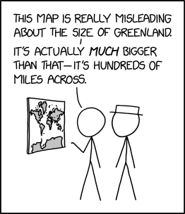
The Mercator projection, depicted in the comic, prioritizes depicting correct angles. This allows for easy course planning at sea, and makes shapes fairly accurate. In exchange, Mercator is often criticized for distorting size: distances near the poles look larger than the same distance near the equator. A common complaint is that Greenland appears as big on the map as Africa, when Africa actually has 14 times as much area as Greenland. When these size distortions are presented out of context, they can create bias and misconceptions about different places.
Cueball's dialogue leads the reader to expect this complaint. However, instead of comparing relative sizes of two landmasses within the map, Cueball compares the absolute sizes of the depiction of Greenland and the actual Greenland. On a typical world map, Greenland might be centimeters or inches across. Judging from the human characters, the mapped Greenland in this comic might be 10 cm across. In real life, Greenland is about 650 miles or 1,050 km across from east to west. Cueball deems this difference misleading, presenting it as a failure of this specific map or projection.
Of course, this is absurd. The purpose of any map is to present information at a scale (usually much more compactly) at which it is easy to read and interpret. Any actual-size world map would have to be the size of the Earth's surface, in which case it would have few uses. In addition, if a map includes a scale, it enables the user to use the ratio to calculate the actual size of the places depicted (though this would not be possible on a Mercator projection, since the map-to-reality scale is not constant).
The title text is about the fact that regardless of the size of the map there is a certain point where the area on the map is equal to the area at the actual pole at that latitude. This is because a horizontal line on a worldwide Mercator projection corresponds to a line of latitude. While most lines of latitude are thousands of miles (kilometers) long, they become smaller and smaller approaching the poles. As long as the projection (and choice of how much map to print) includes the pole (a point of zero length) expanded out as a measurable edge of the map, there will be a line of latitude around each pole whose length would equal the width of the map that Cueball is looking at (though the specific line would be different depending on the size and precise geometry of the map). If Cueball's map were 1 m wide, then this line of latitude would be at 89.999998568° N or S - that is, the line of latitude there would be a circle with a circumference of 1 m around each of the poles. Of course, in order for the map to actually include (say) the northern of those latitude lines as well as the equator, it would have to be over 3 meters tall.
The idea of a 1:1 map was expanded in Jorge Luis Borges's "On Exactitude in Science".
Mercator projections have been mentioned previously in 977: Map Projections, 2082: Mercator Projection, and 2613: Bad Map Projection: Madagascator. The misleading size of Greenland on the Mercator projection is also the object of 2489: Bad Map Projection: The Greenland Special.